-
수도권
토지이용
-
토지이용
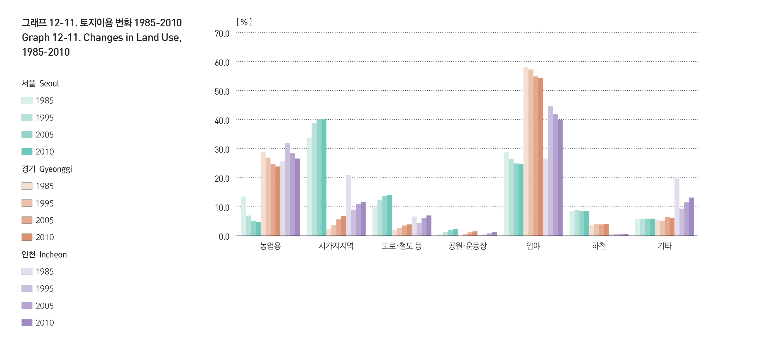
수도권의 지목별 토지이용 변화추이를 살펴보면 농업용, 임야 토지면적의 비율은 감소하고 있으며, 시가지 지역과 공공용지의 토지면적 비율은 증가하는 추세이다.
인천의 경우는 행정구역 확장으로 시가지의 비율은 급격하게 감소하였으나 실제 시가지 면적은 약 43㎢에서 약 86㎢로 증가하였다.
서울시는 농업용 면적 비율이 1985년과 2010년 사이에 8.7%가 감소하였으며, 경기도의 경우에도 5.1%가 감소하였다. 반면, 시가지 지역의 면적은 같은 기간에 서울 6.5%, 경기도 4.4%가 증가하였다. 이러한 시가화는 특히 간선도로 주변을 따라 크게 나타나고 있으며 기존의 경인, 경부축과 더불어 경의축, 중부축, 경원축을 따라 확산되고 있다.
LAND USE
The trends in land use by designated purpose shows that the proportion of agricultural and forest land is decreasing while that of built-up areas and public land is rising. Incheon, however, saw a huge, rapid decrease in the proportion of built-up areas because of administration boundary adjustments, but the actual surface area of built-up areas increased from 43㎢ to 86㎢. In particular, Seoul saw an 8.7% decrease in agricultural land, while Gyeonggi-do saw a 5.1% decrease. On the other hand, the surface area of built-up areas increased by 6.5% and 4.4% in Seoul Gyeonggi-do, respectively. The change in land use is most apparent near the arterial roads, which have been decentralizing along Seoul-Incheon and Seoul-Busan axes.

출처 : 환경부, 수도권 토지피복도, 2009년
출처 : 통계청, 국가통계포털(KOSIS)