-
수도권
지형
-
지형
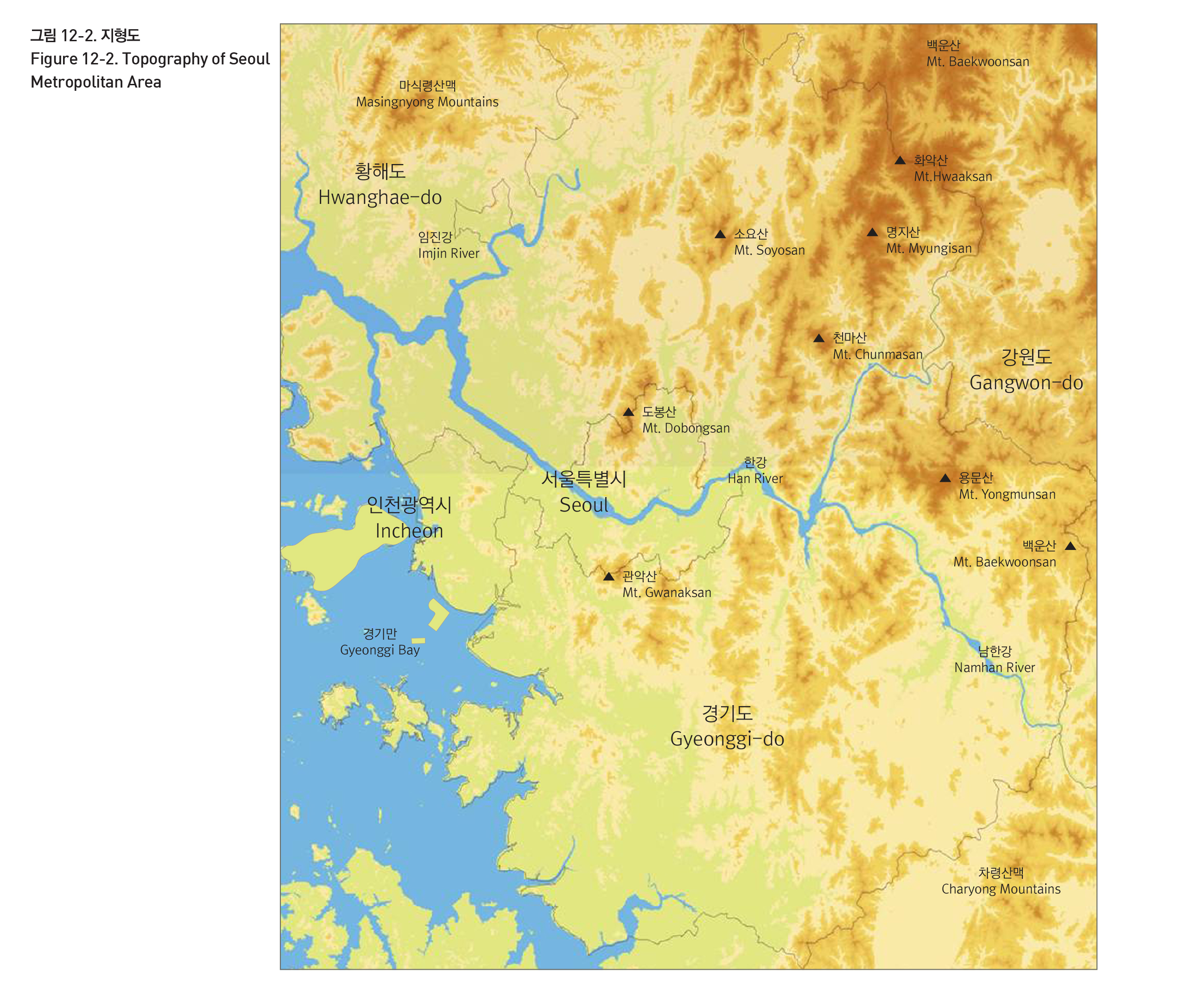
수도권은 우리나라의 심장부에 해당하는 서울을 중심으로 지난 반세기 동안 국가의 경제성장과 궤를 같이 한 지역이다. 수도권을 서울과 하나의 대도시권으로 인식할 필요가 있으며, 서울을 제대로 이해하기 위해서는 서울시의 행정구역을 넘어서서 실질적 영향이 미치는 지역, 즉 서울대도시권이라는 광역차원에서 접근할 필요가 있다. 서울대도시권의 공간적 범위는 학자들마다 다르게 설정되기도 하나, 법률상 수도권의 정의는 서울시와 인천시, 경기도를 포괄하는 지역이다. 수도권은 우리나라 중부의 서쪽에 위치하며, 서쪽에 황해의 경기만, 북서쪽에 황해도, 동쪽에 강원도, 남쪽에 충청도와 접하고 있다. 황해도와의 경계선에는 마식령산맥, 충청북도와의 경계선에는 차령산맥이 있다. 수도권의 서부는 대체적으로 평탄한 충적평야인 데 반하여 동북부에는 고도 1,00m 이상의 높은 산들이 솟아있다. 가장 중요한 수계는 강원도에서 발원하는 한강수계이며, 수도권을 동서로 가로지르는 한강은 자동차 및 철도 교통이 발달하기 이전까지 중요한 내륙수로의 역할을 수행하였다.
TOPOGRAPHY
For the past half century, Seoul metropolitan area has shared in the economic progress of Korea and Seoul and enjoyed intimate ties to the activities of the city. The legal definition of Seoul metropolitan area defines it as the agglomerate of Seoul, Incheon, and Gyeonggi-do.
While the western part of Seoul metropolitan area is mostly an alluvial plain, the northeastern part of the area features high mountains that are more than 1,000m above sea level. The most important water system is the Han River water system, originating from Gangwon-do. Traversing Seoul metropolitan area from east to west, Han River served as a major inland waterway before the development of automobiles and train transportation.
출처 : 서울연구원, 위성사진, 2011년
출처 : 서울연구원


